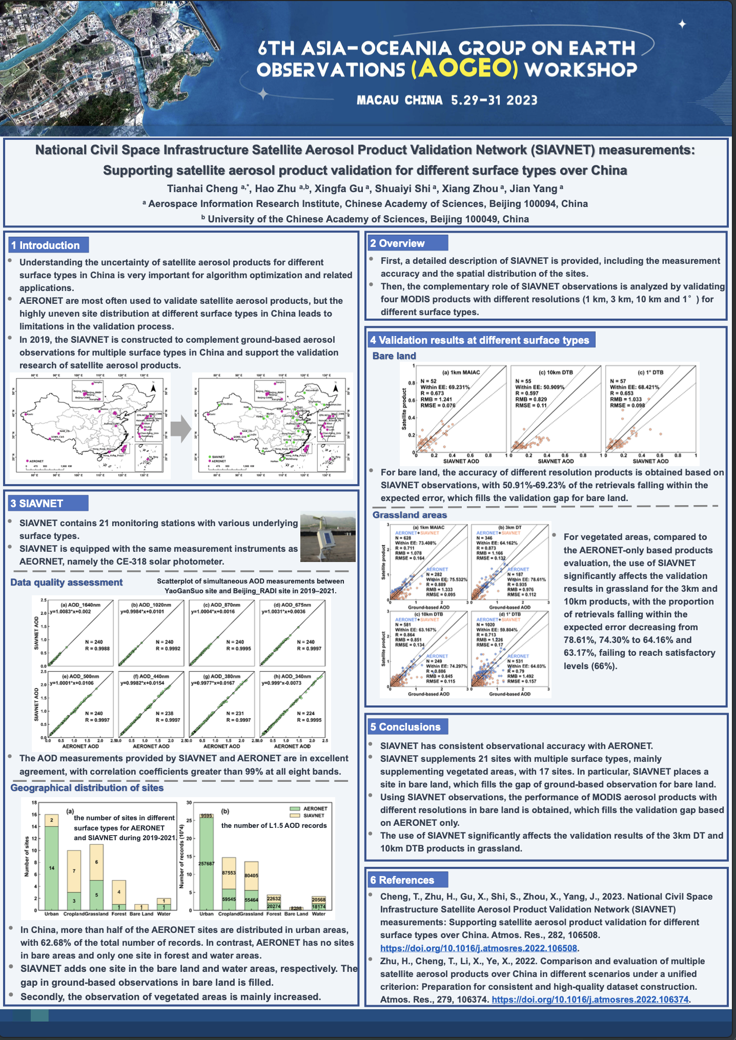
Welcome to 6th AOGEO Workshop

Asia-Oceania Group on Earth Observations (AOGEO), one of Regional GEOs of global GEO, takes great responsibility in coordinating different stakeholders and activities that focus on regional needs and promote GEO Engagement Priorities in Asia-Oceania region.

The 6th AOGEO Workshop will be held in person in Macau, China from May 29-31, 2023, followed by 2023 International Training Workshop in June. The annual AOGEO Workshop brings together the GEO community in Asia Oceania region to exchange scientific and technical views on Earth observations and their applications, and showcase their technical advances to the global community.

In the following days, we are very honored to invite colleagues and friends across GEO and AOGEO community to participate in this annual event. It is our hope that our participants could listen carefully to each presentation and share your innovative and insightful ideas with others. We are very expected to meet you face-to-face at the beautiful campus of University of Macau(UM).

Overview


Theme


Demand-driven Advancements in Earth Observation Technology and Application

Purpose


  • AOGEO workshop is committed to providing a platform for AOGEO participants to widely exchange good practices, discuss major challenges, transmit GEO latest trends, aiming to achieve harmonious development of AOGEO work, fast transmission of GEO spirit to AOGEO community, and empowering the use of EO for local impact;

  • Provide a platform for AOGEO working groups and researchers to review lessons learnt under the workshop theme, share progress and good practice in their EO application, analyze and explore ways out of current challenges in AO region;

  • Keep pace with GEO community’s concerns and current events, foster dialogues between GEO Work Programme (GWP) activities, AOGEO TGs, IPS working groups and researchers involving related topics, to stimulate potential integrative EO-based regional solutions and strengthen the engagement of regional GEO while understanding the latest news and trends of GEO Symposium;

  • Continue to focus on how to develop regional capacity through integrating GEO emerging topics into AOGEO’s work, deliver open data and open knowledge to local users, and make our voice heard by more people decisions and actions for the benefit of humankind are informed coordinated, comprehensive, and sustained observations.

Announcement


Agenda at a Glance


Beijing Time May 29, Monday May 30, Tuesday May 31, Wednesday


09:00-12:00
Opening Ceremony (50min)

Break and Group Photo (20min)
Thematic Session 1: Views of GEO Infrastructure in The Next Generation(40min)


Break(10min)


Break(10min)
Closing Ceremony(90min)
12:00-13:30 Lunch


13:30-16:30


Break(30min)
Poster Exhibition(110min) AOGEO CB Meeting(Closed-door Meeting)(110min)

Break(10min)
Opening Ceremony of 2023 Online International Training Workshop(60min)

Campus Tour of the University of Macau(120min)


Time zones reference:

UTC+1:00UTC+5:00UTC+8:00UTC+9:00UTC+10:00
GenevaKathmanduBeijingSeoul & TokyoCanberra
03:00-10:3006:45-14:1509:00-16:3010:00-17:3011:00-18:30

Programme


Day 1 (29 May)
Opening Ceremony

Moderators: Xingfa GU(AIRCAS)

    09:00 - 09:50

  • Welcome Remarks by Welcome Remarks from GEO China Secretariat, Jing ZHAO, Director general, National Remote Sensing Center of China

  • Welcome Remarks by the University of Macau

  • Welcome Remarks by GEOSEC

  • Welcome Remarks by AOGEO Co-chairs

    Megan LEWIS (The University of Adelaide)

    Mariko HARADA (MEXT)

    Xingfa GU (AIRCAS)


    09:50-10:10

  • Break and Group Photo


Thematic Session 1: Views of GEO Infrastructure in the Next Generation

Moderator(s): Yuqi BAI(Tsinghua University), Osamu OCHIAI(JAXA)


Speaker(s)
Osamu OCHIAI
JAXA
Qihao WENG
The Hong Kong
Polytechnic University
Florian FRANZIKAKIS
GEO Secretariat

    10:10-10:50

  • GEO Infrastructure moving forward: what components to integrate and what role is there to play for Regional GEOs? [pdf] [video]

    Prof. Florian FRANZISKAKIS, GEO Secretariat

  • Progress towards the post-2025 strategy for GEO

    Prof. Osamu OCHIAI, JAXA

  • GEO Global Urban Observation and Information Initiative: Implementation Plan for 2023-2025 and Beyond

    Prof. Qihao WENG, The Hong Kong Polytechnic University


Thematic Session 2: Application-oriented Data Fusion and Technology Integration

Moderator(s): Xingfa GU(AIRCAS), Megan LEWIS(The University of Adelaide)


Speaker(s)
Yan LIU
Aerospace
Information
Research Institute,
Chinese Academy
of Sciences
Maggie ARNOLD
Geoscience Australia
Matt STEVENTON
CEOS
Ping TANG
Aerospace
Information
Research Institute,
Chinese Academy
of Sciences
Tao HE
Wuhan Universit
Hankui ZHANG
South Dakota
State University

    10:50 - 12:00

  • Production and Key Technology for Gaofen 16 meter Analysis Ready Dat [pdf] [video]

    Prof. Ping TANG, Aerospace Information Research Institute, Chinese Academy of Sciences

  • Progress of ARD and Virtual constellation from CEOS [pdf] [video]

    Prof. Matthew STEVENTON, CEOS

  • Development of a global 30m land surface parameter product suite Hi-GLASS for resource and environment monitoring [pdf] [video]

    Prof. Tao HE, Wuhan University

  • Landsat analysis ready data: algorithms and application demonstrations with deep learning based land cover mapping [pdf] [video]

    Prof. Hankui ZHANG, South Dakota State University

  • Spectrum Earth Targeting GEO’s Needs, Integrating Multi-source Data, and Lowering Barriers of Application [pdf] [video]

    Prof. Yan LIU, Aerospace Information Research Institute, Chinese Academy of Sciences

  • Progress of Data Cube [pdf] [video]

    Prof. Maggie ARNOLD, Geoscience Australia


    12:00 - 13:30

  • Lunch


Practices and Activities in IPS region

Part 1. Himalayan Region

Moderator(s): Shanlong LU(AIRCAS) + Birendra Bajracharya(ICIMOD)


    13:30 - 16:00

  • Brief opening remarks

    Prof. Xiang ZHOU, Aerospace Information Research Institute, Chinese Academy of Sciences

  • Earth observation for understanding our changing environments in the Hindu Kush Himalaya: Opportunities and challenges [pdf] [video]

    Prof. Birendra BAJRACHARYA, ICIMOD

  • Cloud Computing- based System for SDGs Monitoring and Assessment in the HKH region [pdf] [video]

    Prof. Jia Song, Aerospace Information Research Institute, Chinese Academy of Sciences/ IGSNRR

  • Capacity building of Remote Sensing Monitoring for Marine and Coastal Ecosystems in PICTs [pdf] [video]

    Prof. Wenting CAO, The Second Institute of Oceanography, Ministry of Natural Resources


  • Panel discussions

    Prof. A.K.M. Saiful ISLAM, Bangladesh University of Engineering and Technology

    Prof. Kunpeng WU, Yunnan University, China

    Prof. Muhammad Hasan Ali BAIG, Institute of Meteorology and Geophysics, Pakistan Meteorological Department

    Prof. G.M. Tarekul ISLAM, Bangladesh University of Engineering and Technology

    Prof. Xidong CHEN, North China University of Water Resources and Electric Power

    Prof. Binod BANIYA, Environmental Science, Tribhuvan University, Nepal

    Panel Discussion


Part 2. Mekong River Basins

Moderator(s): Li JIA (AIRCAS) + Ix HOUR (MRC)


  • The MRC Drought Forecasting and Early Warning System (DFEWS) [pdf] [video]

    Prof. Ix HOUR, Mekong River Commission Secretariat (MRCS), Cambodia

  • Surface Water Mapping and Flood Monitoring in the Mekong Delta Using Sentinel-1 SAR Time Series [pdf] [video]

    Prof. Massimo MENENTI, Aerospace Information Research Institute, Chinese Academy of Sciences / TUD, China / Netherlands

  • Monitoring Agricultural Drought and Waterlogging over Mainland Southeast Asia: Surveying Soil from the Sky [pdf] [video]

    Prof. Tianjie ZHAO, Aerospace Information Research Institute, Chinese Academy of Sciences, China

  • Geospatial information applications for rice monitoring in CLM countries [pdf] [video]

    Prof. Panu Nuangjumnong, GISTDA, Thailand

  • Monitoring and Modelling of Hydrological Extremes in the Mekong River Basin [pdf] [video]

    Prof. Hui LU, Tsinghua University, China

  • Geospatial Modelling for Estimation of PM2.5 in Thailand [pdf] [video]

    Prof. Woranut Chansury, GISTDA, Thailand

  • Water Stress and Drought Monitoring Using Satellite Observations [pdf] [video]

    Prof. Li JIA, Aerospace Information Research Institute, Chinese Academy of Sciences, China

  • Using Satellite Information for Vulnerability Assessment: A Case Study of the Philippines [pdf] [video]

    Prof. Aileen Guzman, Ateneo de Manila University, Philippine


Day 2 (30 May)
Thematic Session 3: Global Ecological Environment Monitoring and the Global Ecosystems Atlas

Moderator(s): Qinhuo LIU (AIRCAS) + Hiroyuki MURAOKA (Gifu University)


Speaker(s)
Qinhuo LIU
Aerospace Information Research Institute, Chinese Academy of Sciences
Alfredo R. HUETE
University of Technology Sydney
Le YU
Tsinghua University
Bo ZHONG
Aerospace Information Research Institute, Chinese Academy of Sciences
Jing LI
Aerospace Information Research Institute, Chinese Academy of Sciences
Xinyu ZHANG
Institute of Geographic Sciences and Natural Resources Research, CAS
Aamir SALEEM
PMAS-AridAgriculture University, Rawalpindi, Pakistan

    09:00 - 12:20

  • Global Ecological Environment Monitoring and the Global Ecosystems Atlas [pdf] [video]

    Prof. Qinhuo LIU, Aerospace Information Research Institute, Chinese Academy of Sciences

  • Investigating climate impacts on landscape phenology and biodiversity using multi-sensor earth observations [pdf] [video]

    Prof. Alfredo R. HUETE, University of Technology Sydney

  • Near real time global land use/cover change (LUCC) mapping and ecosystem mapping [pdf] [video]

    Prof. Le YU, Tsinghua University

  • The Temporally Consistent Landcover Product using Time Series of Chinese GaoFen-1/6 Satellite Data [pdf] [video]

    Prof.Bo ZHONG, Aerospace Information Research Institute, Chinese Academy of Sciences

  • Integrated remote sensing monitoring of ecosystem over Asia-Oceania hot areas [pdf] [video]

    Prof. Jing LI, Aerospace Information Research Institute, Chinese Academy of Sciences

  • Comprehensive Observations and Applications for Typical Terrestrial Ecosystems in the Belt and Road Area of China and Central-Asia [pdf] [video]

    Prof. Xinyu ZHANG, Institute of Geographic Sciences and Natural Resources Research, CAS

  • Monitoring, threats and protection of biodiversity in Pakistan under current scenario of climate change [video]

    Prof. Aamir SALEEM, PMAS-AridAgriculture University, Rawalpindi, Pakistan


    10:20 - 10:30

  • Break


Thematic Session 4: Earth Observation Satellite Data Sharing and Knowledge Hub

Moderator(s): Jinnian WANG(Guangzhou University) + Junliang QIU(University of Padova)


    10:30 - 12:00

  • A Knowledge-Driven Service Framework for China High-resolution Earth Observation System (CHEOS) [pdf] [video]

    Prof. Limin ZHAO, Aerospace Information Research Institute, Chinese Academy of Sciences

  • Construction Progress of New China GEOSS Components [pdf] [video]

    Prof. Jian WANG, Aerospace Information Research Institute, Chinese Academy of Sciences

  • Flood Dynamics Monitoring in China's Rural Areas Using GEE Online Computing Platform [pdf] [video]

    Dr. Junliang QIU, Department of Land, Environment, Agriculture and Forestry, University of Padova

  • The Construction of Data Sharing Center and The Development of Representative Online Data Processing Toolboxes for Key Regional Applications [pdf] [video]

    Prof. Xiankun YANG, School of Geography and Remote Sensing, Guangzhou University

  • Development, Sharing and Applications of JLS-5M Datasets from CGSTL's Medium-high-resolution Multispectral Satellites [pdf] [video]

    Dr. Xing ZHONG, Chang Guang Satellite Technology Co.


    12:00 - 13:30

  • Lunch

Poster Exhibition

Moderator(s): Juan LI(AIRCAS)

  • 13:30 - 15:30

/
AOGEO CB Meeting(Closed-door meeting)


    Day 3 (31 May)
    Thematic Session 5: Showcase of Application and Capacity Building for Local Needs

    Moderator(s): Florian FRANZISKAKIS(GEO secretariat), Xiang ZHOU(AIRCAS)


      09:00 - 10:20

    • Progress of AOGEO capacity development

    • Progress in capacity building on Earth observation applications for local needs in the Hindu Kush Himalaya [pdf] [video]

      Dr. Poonam TRIPATHI, Training Analyst, SERVIR-HKH Initiative, ICIMOD

    • Capacity Development of Geoinformation Technology -Practical Exploration in the University [pdf] [video]

      Prof. Xi LI, Professor, Wuhan University

    • Earth Observation and data sharing platforms: An Indian Experience [pdf] [video]

      Prof. Pankaj KUMAR, Professor, Department of Geography, University of Delhi

    • Mutual Development for Earth Observation and Youth Competence

      Prof. Guoqing Li, Aerospace Information Research Institute, Chinese Academy of Sciences

      Dr. Mona Allam, Egypt

    • Discussion


      10:20 - 10:30

    • Break


    Closing Ceremony

    Moderator(s): Xingfa GU(AIRCAS)


      10:30 - 12:00

    • Summary report from each session

    • Plans for 2024 AOGEO Workshop

    • The Publishing of 2023 AOGEO Announcement

    • Closing Remarks


      12:00 - 13:30

    • Lunch


    Opening Ceremony of 2023 Online International Training Workshop

    Moderator(s): Xiang ZHOU(AIRCAS)


      13:30 - 14:30

    • Opening Remarks from General Director of National remote sensing center of China

      Jing ZHAO

    • Opening Remarks from AOGEO-RCCD, ICIMOD

      Birendra BAJRACHARYA

    • Opening Remarks from Deputy Director General, AIRCAS

      Bing ZHANG

    • Opening Remarks from Director, University of Ruhuna

      Disna RATNASEKERA

    • Opening Remarks from Scientific and Technical Officer at Group on Earth Observations (GEO)

      Wenbo CHU

    • Opening Remarks AOGEO co-chair

      Xingfa GU

    • Keynote Speech: Earth observation in the age of AI and bigdata

      Prof. Xin Li, ITP CAS

      Keynote


      14:30 - 16:30

    • The Campus Tour of the University of Macau

Exhibition


Exhibition Date and Time
Tuesday, May 3013:30-15:00

Poster(s)

Logistics


Passport and Visa

If you need an official invitation letter to justify your travel and apply for your visa, please register and the invitation will be sent to your e-mail.

Registration fee

The 6th AOGEO Workshop is free of charge for registration.

Meeting Venue

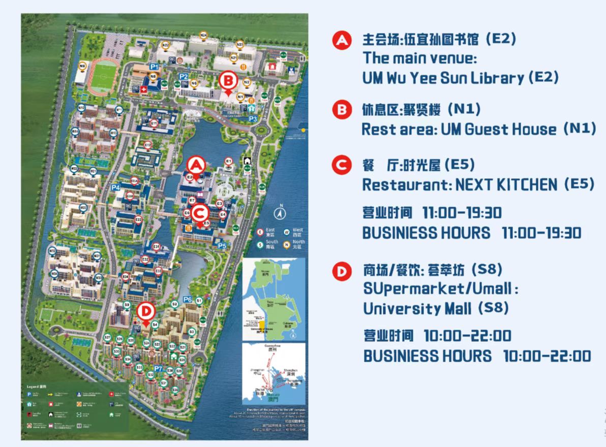
This Workshop will be held offline in the University of Macau Library(E2-G012). The meeting hall will accommodate all participants(50-100 people), well equipped with meeting facilities.

Catering

This workshop will offer a welcome dinner and several coffee breaks, free of charge.

Hotel

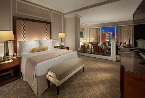
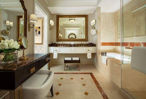
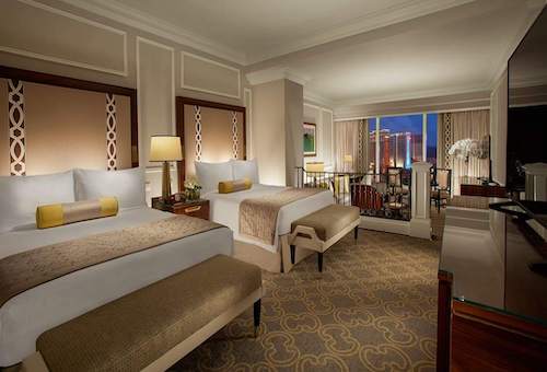
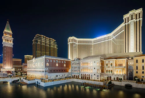
You can consider other hotels outside the University of Macau. The Venetian Macao (Link) is recommended. Here is some room type for this hotel


Room TypeSizePrice (Without Breakfast)
Royale Deluxe Suite(Double)70m² Mop1654+
Bella Deluxe Suite(Twins)70m² Mop1792+

Transportation

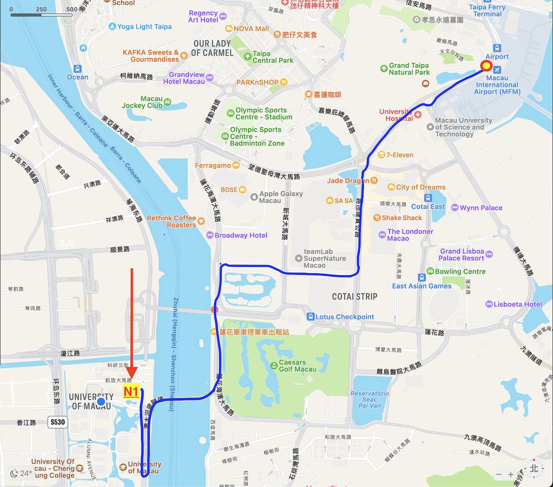
Participants are recommended to arrive at Macau International Airport, which is no more than 10 kilometres away from the University of Macau.

Training Workshop


Please click for more information

Hosts
National Remote Sensing Center of China (NRSCC)
Asia-Oceania Group on Earth Observations (AOGEO)

Organizers
Aerospace Information Research Institute, Chinese Academy of Sciences (AIRCAS)
International Centre for Integrated Mountain Development (ICIMOD)
University of Ruhuna, Sri Lanka

Contact Us


Secretariat
Aerospace Information Research Institute, Chinese Academy of Sciences
E-mail: aogeo_China@aircas.ac.cn, weijiacao@um.edu.mo